NEW ZEALAND
DILLMAN’S TOWN, KUMARA,
BRUNNER BRIDGE COAL MINING, PORT OF NELSON
Written from first hand research by George W. Randall, co-founder in July 1996 and former
DILLMAN’S TOWN, KUMARA,
BRUNNER BRIDGE COAL MINING, PORT OF NELSON
Written from first hand research by George W. Randall, co-founder in July 1996 and former
Vice Chairman of Kinloch Castle Friends' Association.
Late 19th Century photographs from the albums of Sir George Bullough, (he was knighted in 1902), in the library of his Highland home, Kinloch Castle, Isle of Rum, Scotland,
Late 19th Century photographs from the albums of Sir George Bullough, (he was knighted in 1902), in the library of his Highland home, Kinloch Castle, Isle of Rum, Scotland,
and collected during his three-year long world tour 1892-1895.
B L O G 7 7 * FROM ALBUM XII
*<>*<>*<>*<>* Time of visit to New Zealand November 1894. *<>*<>*<>*<>*
 | ||||||
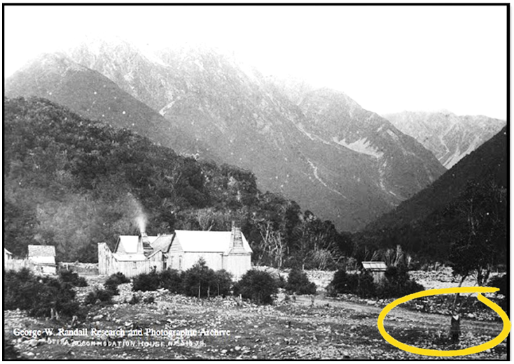
SLUICING AT DILLMAN’S TOWN, KUMARA, NEW ZEALAND
No. 179 JR Album XII * Image 21 * Size 8 x 5¼ inches by James Ring. 
Located on the
west coast of New Zealand’s South Island, nineteen miles south of
Greymouth, the town of Kumara was founded in 1876.
The following
year it became a borough and centre of the countries
gold mining
industry following discovery of the precious metal
at Dillmanstown,
two miles to the south-east.
Within twelve
months the population swelled to over 4,200,
the town
eventually boasting fifty public houses, its own hospital
and fire
brigade. Today the population is less than three-hundred
and all the pubs
have gone.
From 1879 British born
Richard John Seddon, nicknamed “King Dick”, was liberal member of the New Zealand House of Representatives for the constituency of Hokitika, which included Kumara and Dillmanstown. He was elected the countries fifteenth Prime Minister in 1893 a position he held until his death in 1906 while still in office, twelve days short of his sixty-fifth birthday.     
SLUICING AT DILLMAN’S TOWN, KUMARA, NEW ZEALAND No. 179 JR
Album XII * Image 21 * Detail from full size 8 x 5¼ inches by James Ring.
In 1875 coarse
gold was found in glacial gravels of the Taramakau River two
miles east
of Kumara triggering the gold rush of July 1876 when 3,000 prospectors
descended on the
area which became known as Dillmanstown.
The gold was intermingled
with large rocks and gravel, called overburden,
eighty feet thick.
The easiest way
of recovering the precious metal was by hydraulic sluicing.
For the
next twenty years steam driven high pressure jets of water sluiced away
tons of gold
bearing alluvial mud, sand and gravel to be screened and sorted,
in the process
500,000 ounces of gold were recovered.
* >< * >< * >< * >< * > + < * >< * >< * >< * >< *
THE COAL MINES OF BRUNNERTON - THE OLDEST IN NEW ZEALAND
In July 1847
while exploring the Grey River upstream of Greymouth by canoe,
twenty-six year
old surveyor and explorer Thomas Brunner discovered deposits of coal.
 Brunner was born
in the English university town of Oxford in Brunner was born
in the English university town of Oxford in April 1821, where he studied architecture and surveying.
In 1841 he joined the fledgling New Zealand Company,
a
British company at the forefront of colonising the country
first sighted by Abel Tasman two hundred years earlier
and first visited by Captain James Cook
in 1769.
 Based at Nelson, Tasman Bay, Brunner oversaw the laying of roads and surveyed South Island's interior for its potential
to supply the food and material needs of a growing colony. Based at Nelson, Tasman Bay, Brunner oversaw the laying of roads and surveyed South Island's interior for its potential
to supply the food and material needs of a growing colony. In 1846, accompanied by Charles Heaphy, a draughtsman, also in the employ of the New Zealand Company, and a Mãori named Kehu - a man described as “an instinctive navigator, a Mãori guide extraordinaire”, Brunner embarked on an extensive exploration of the west coast of South Island and the Grey River.
The small group was away for five hundred and fifty days
during which they not only discovered
the Brunnerton coal outcrop but surveyed
sites for the soon to be towns of Greymouth and Westport. Brunner was appointed Government Surveyor in
1851.
He retired in 1869 and died on the 22nd
of April 1874 aged fifty-three.

Album XII * Image 26 *
Size 8 x 5½ inches by James Ring.
View downstream towards Greymouth about eight miles. The south bank left.
Crossing the
Grey River, so named by Thomas Brunner after the prominent 19th
century politician
and 11th Premier of New Zealand Sir George Grey, K.C.B., the Brunner suspension bridge was built in 1876 to connect the Tyneside Coal Mine on the southern bank
with Brunner
mine, opened in 1864, on the northern bank. 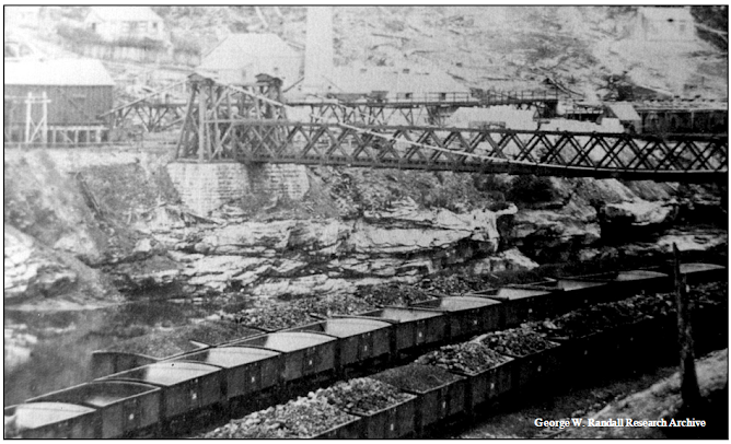    SEATON'S RAILWAY HOTEL (left) TYNESIDE COLLIERY WORKINGS BRUNNERTON BRIDGE, NEW ZEALAND. No. 276 JR.
Album XII * Image 26 * Detail from full size 8 x 5½ inches by James Ring.   ....................................................................

Coal mining commenced at Brunnerton in 1864.
Mined by Matthew Batty, the first forty tons were sent by barge to Greymouth, a distance of eight miles, and then shipped to Nelson by Reuben Waite a Greymouth storekeeper.  The barges were
returned to the mine by being hauled upstream by teams of horses, a process which was both slow and cumbersome. The barges were
returned to the mine by being hauled upstream by teams of horses, a process which was both slow and cumbersome. In addition the mouth of the river was dangerous to shipping, an unsatisfactory transport combination for commercial coal production
which lasted until 1876 when the rail line from Greymouth to the coalfield was laid. This vital link was extended to Reefton four years later, to Otira in 1900, Christchurch in 1923 and Westport in 1942.
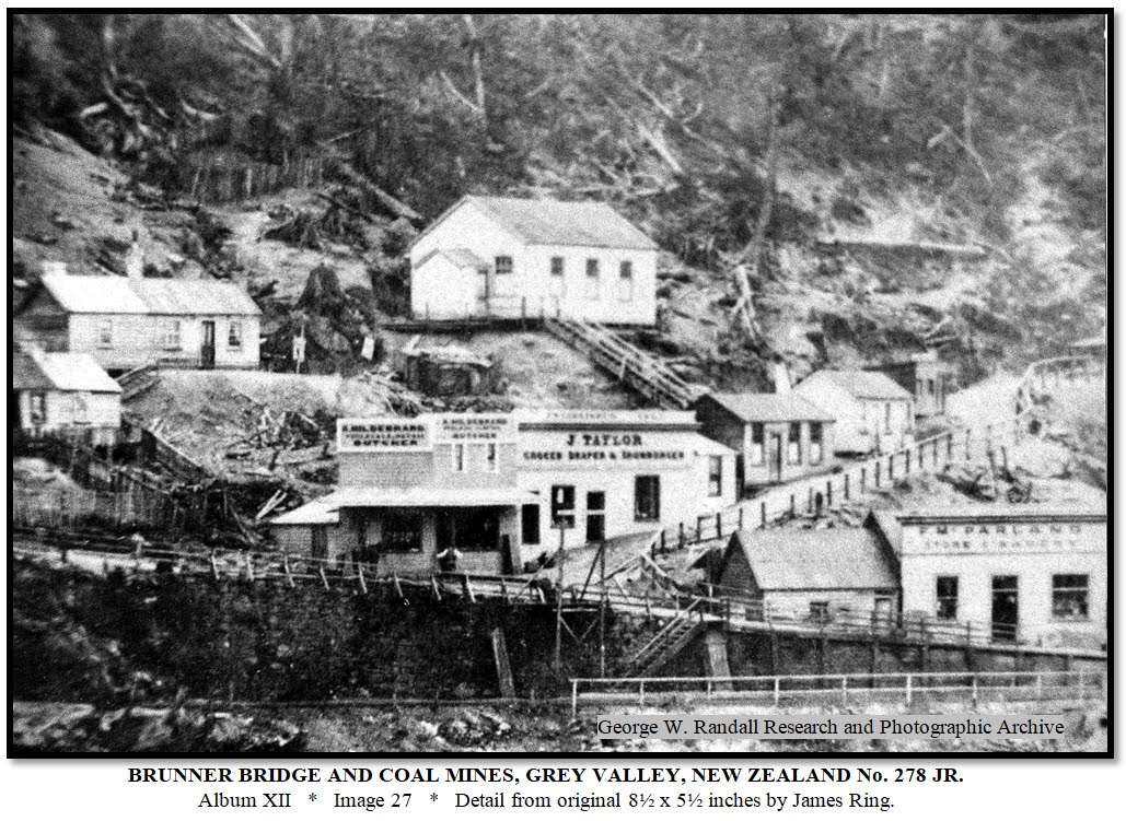
Neil Bernard, Butcher;
J. Taylor, Grocer, Draper, Haberdasher; P. McFarland, Store and Bakery. 
Brunner Bridge
Coal Mine Rail Siding, Grey Valley.
On Thursday the
26th of March 1896
disaster struck Brunnerton Mine.
On Thursday the
26th of March 1896 at 9.25 a.m. disaster struck Brunnerton
Mine.
A sound like
artillery fire was heard followed by smoke billowing from the pithead.
The explosion, which occurred sump
side of the dip-working deep inside the mine, caused
the death of
sixty-five miners - men and boys, almost half the underground workforce;
its force
leaving the “railway line and trucks twisted and smashed.”
Surface
buildings at the entrance were undamaged.
At the time of
the accident the mine was under the administrative control of
Mr. James
Bishop, M.I.M.E., a qualified and certified coal-mine manager with
twenty-five
years of experience, thirteen years of which being at Brunnerton Mine.
Immediately a crowd gathered. Mr. Bishop, accompanied by an underground engineer,
descended into the mine to investigate. When they failed to return miners from other shifts followed and found them unconscious. As rescuers moved further into the diggings a number were also overcome by fumes. As the unconscious rescuers were brought to the surface hope rose as they were mistaken
for the rescued only to be dashed as the enormity of the tragedy became apparent.
Meanwhile help was arriving as news of the disaster spread.
The subsequent commission of inquiry found no blame could be attached to management of the mine, the explosion being the result of human error. It concluded a charge had been placed the wrong way round in a part of the mine where no one should have been working.
The original
twenty-one year lease for Brunner Mine situated on the north side of the Grey
River where it flows through a confined rocky gorge was granted on the 1st of January 1874
and encompassed an area of 1,280 acres, the mine itself extending to about 230 acres.
the holder at the time who in January 1887 obtained a new lease for a term of sixty-three years. In 1888 Mr. Kennedy transferred his lease to the Grey Valley Coal Company who surrendered it in December 1894 for a new lease under the conditions of “The Coal-mines Act, 1891.” With the consent of the Minister, this lease was transferred on the 19th of October 1895 by deed of assignment to the Greymouth-Point Elizabeth Railway and Coal Company (Limited), this company being the responsible owner of the mine at the date of the accident. The Disaster Inquiry revealed in June 1874 Martin Kennedy had "acquired a considerable share in the coal mines at Brunnerton" and from that date was proprietor of Brunnerton Mine up to 1888 when the lease was transferred to the Grey Valley Coal Company of which Mr. Kennedy was a fourth partner in the whole since amalgamation with the West Point Company. The Westport Company holding being two-fourths, Mr. Kennedy one-fourth and the Union Steamship Company one-fourth; the name of the company being the Grey Valley Coal Company (Limited) of which Mr. Kennedy was the managing director. >< ><>< ><>< ><>< ><>< ><>< ><>< ><>< ><>< ><>< ><>< ><>< ><
* Lured by the
discovery of gold twenty year old Martin Kennedy his brother,
sons of a farmer
in Tipperary, Eire, arrived in Australia in January 1860.
On the 20th
of May 1861 thirty-seven year old Tasmanian prospector Gabriel Read
struck gold
close to the surface by the Tuapeka River, Otago, New Zealand,
triggering the
1861 Gold Rush, the site becoming known as Gabriel’s Gully.
It was not long
before the Kennedys heard of the “rich discoveries in Otago”
 and after twelve
months actively prospecting with little result in Victoria, Australia, they decided to
cross the Tasman Sea and set up business as merchants in Queenstown.
and after twelve
months actively prospecting with little result in Victoria, Australia, they decided to
cross the Tasman Sea and set up business as merchants in Queenstown.
Following more
promising discoveries of gold by the Taramakau River along the West Coast in
1864 Martin Kennedy moved to Greymouth where for the nexttwenty years he was
a successful merchant becoming a leading figure in the business community.
In
1874 he acquired “a considerable share in the coal mines at Brunnerton”.
By 1880 his
mining interests necessitated giving up his mercantile business in order to devote
himself entirely to them as a coal-mine proprietor. In 1888 he amalgamated his
colliery with Westport Company’s interests a Brunnerton,
forming the Grey
Valley Coal Company. Mr. Kennedy owned a sheep run in Wairarapa, was a director of several companies and managing director of the parent company of brewers Staples & Co., at Thorndon, Wellington, North Island, as well as being a director of the Bank of New Zealand.
In 1876 he was
returned as member for the Grey Electorate District of the House of
Representatives.
Martin
Kennedy, K.S.G., died in Wellington on the 25th of August 1916. >< ><>< ><>< ><>< ><>< ><>< ><>< ><>< ><>< ><>< ><>< ><>< ><
NELSON  Album XII Image 29
Full size: 9½ x 7 inches. Original Photo. by Tyree No. 1023   Album XII Image 30 Full size: 9½ x 7 inches. Original Photo. by Tyree No. 2019.  Album XII Image 30 Full size: 9½ x 7 inches. Detail from original Photo. by Tyree No. 2019  A steam tram.
>< ><>< ><>< ><>< ><>< ><>< ><>< ><>< ><>< ><>< ><><
REVIEWED PLUS ADDED MATERIAL 31 MARCH 2024
|