TASMANIA & NEW ZEALAND
HOBART, DUNEDIN, PORT CHALMERS, NELSON,
Taiaroa Head Royal Albatross Colony.


.
THE AUTHOR - GEORGE W. RANDALL:
.


.

.


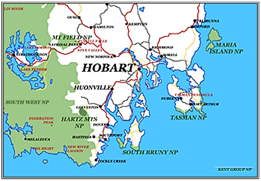
Map from Encyclopædia
Britannica Ninth Edition Volume XXII 1892.
, FRONT COVER OF ALBUM XI - TASMANIA NEW ZEALAND  |
>*<>*<>*<>*<>*<>*<>*<>*<>*< >*<>*<>*<>*<>*<>*<>*<>*<>*<


HOBART
Album XI * Image 1 * Size 9 x 7 inches.
Original by John Watt Beattie, Photographer, Hobart.
.


Map: Encyclopǽdia Britannica Volume XXII 1892
.

HOBART
Album XI * Image 1 * Detail from full size 9 x 7 inches.
Original by John Watt Beattie, Photographer, Hobart.


HOBART FROM EXHIBITION TOWER
Album X * Image 18 * Full size 9 x 6¾ inches.
Original by John Watt Beattie, Photographer, Hobart.
.
HOBART FROM GLEBE.
Album X * Image 19 * Detail from full size 9 x 6¾ inches.
Original by John Watt Beattie, Photographer, Hobart.
.

Album X * Image 20 * Size 9 x7 inches
Original by John Watt Beattie, Photographer, Hobart.

Album X * Image 20 * Detail from full size 9 x7 inches
Original by John Watt Beattie, Photographer, Hobart.
.
 HOBART FROM BAY.
 Album X * Image 21 * Full size 9 x 6¾ inches.
Original by John Watt Beattie, Photographer, Hobart.
.


.


HOBART FROM BELLERIVE.
Album X * Image 22 * Detail from full size 9 x 7 inches.
Original by John Watt Beattie, Photographer, Hobart.

TOWN HALL, McQUARRIE STREET, HOBART.
Album X * Image 23 * Detail from full size 9 x 7 inches.
Original by John Watt Beattie, Photographer, Hobart.
.
Album X * Image 24 * Size 9 x 7 inches.
Original by John Watt Beattie, Photographer, Hobart.


    Holy Trinity Church, Hobart, circa.1868.  Album XI * Image 5 * Detail - Full size 9 x 7 inches. Original No. 767B by John Watt Beattie, Photographer, Hobart.   |
 |
| Stained Glass in Holy Trinity Church, 50 Warwick Street, Hobart, Tasmania. (Auguste Fischer, c.1898)  THE PHOTOGRAPHER - JOHN WATT BEATTIE .   .
> *< > *<> *<> *<> *<> *<> *<> *< > *<> *<> *<> *<> *<> *<
|
 |
| Album XI * Image * Size 9 x 7 inches. |


>*<>*<>*<>*<>*<>*<>*<>*<>*< >*<>*<>*<>*<>*<>*<>*<>*<>*<


.


 |
TASMANIAN
INTERNATIONAL EXHIBITION, HOBART 1894-1895. MAIN BUILDING. Album XI * Image 2 * Edited from full size 8½ x 6 inches. Photograph by J. W. Beattie from a drawing by Thomas Searell, F.R.V.I.A., M.S.A.
(Architect Public Works Dept.) . |
An exhibition of industry, science and art held
on the Queen’s Domain, Hobart,
a small hilly area north-east of the city, land that traditionally “belongs to the people”
as commissioned by Governor Sir Henry Young, K.C.M.G., in 1860.
a small hilly area north-east of the city, land that traditionally “belongs to the people”
as commissioned by Governor Sir Henry Young, K.C.M.G., in 1860.
.


Powerhouse Collection
>*<>*<>*<>*<>*<>*<>*<>*<>*< >*<>*<>*<>*<>*<>*<>*<>*<>*<
 |
RAPIDS AT BROWNS
RIVER
Album XI * Image 6 * Size 9 x 7 inches. Original No. 97B by John Watt Beattie, Photographer, Hobart.
.
South of Hobart, Browns River
flows gently eastwards descending 1,522 feet over its 7½ mile course. A perennial river, it is named after Scottish botanist Robert Brown, F.R.S.E. (1773-1858), who collected samples in 1804 shortly before the adjacent area was settled becoming known as
Browns River. It was renamed, Kingston, in 1851. .  .  Triassic Osteichthyans from Tasmania .      |
>*<>*<>*<>*<>*<>*<>*<>*<>*< >*<>*<>*<>*<>*<>*<>*<>*<>*<
 | ||
| UNIVERSITY HOUSE - UNIVERSITY OF
TASMANIA
Album XI * Image
3 * Size 9 x 7 inches.
Original photograph by John Watt Beattie, Photographer, Hobart.NOTE: In the Album the photograph is simply labelled "Building". .
The University
of Tasmania was inaugurated on the 1st of January 1890 and today
.is classed in the top two per cent of universities worldwide.
In mid-1892 it
moved into the former Hobart High School, an ornate sandstone building
on Queen’s Domain, which became known as University House. 
Founded in 1848
by a group of leading churchmen the grand neo-Gothic High School,
was designed by architect Alexander Dawson, originally from Haddington, East Lothian,
Scotland, who emigrated to the then Van Diemen's Land in 1844.
A trained architect with a background in the Civil Branch of the Royal Engineers
at Dover, England, he practiced in Hobart before being appointed Colonial Clerk of Works in 1849, holding the office until 1856 when he accepted the post of Colonial Architect for New South Wales. He resigned in 1862 and left Australia.
The school, built on a grant of land on the Queens Domain by Messrs.
Cleghorn and Anderson,
was for the “instruction of youth in the higher branches of learning as taught in the
superior classical and mathematical schools in England”, and opened in 1850.
In 1892 the building was sold to the
newly established University of Tasmania.
After the
University moved to its current location in Sandy Bay in 1962 the building
was occupied by
the Tasmanian School of Art until 1971.
In 2011 it was re-acquired by the
University of Tasmania after being vacant and
unused for many years. Now known
as Domain House it is undergoing major
conservation and restoration with the intention it can once again play an important
role as part of the University of Tasmania
in the 21st Century. ><<> ><<> ><<> ><<> ><<> ><<> ><<> ><<> ><<> . NEW ZEALAND - SOUTH ISLAND PORT CHALMERS, DUNEDIN, AND ROYAL ALBATROSS COLONY TAIAROA HEAD.      . Dunedin and Port Chalmers, sea port for Dunedin. .  PORT CHALMERS FROM DECK OF STEAMER Album XI * Image 3 * Edited from original size 7½ x 5 inches by Morris Photo No. 3. .
|